Eastie for Eastie: A Community-Based Toolkit for Managed Retreat
Sasaki Foundation Community Design Awards 2018-2019
OVERVIEW
East Boston, or “Eastie”, is a coastal neighborhood faced with rising sea levels and intensifying development pressure. Despite the current demand for housing, ‘retreat’ from high risk areas will likely happen in East Boston in the future due to climate change impacts. This ‘retreat’ may be ‘managed,’ through targeted public policy, disaster response mechanisms, or planning interventions for strategic abandonment, or ‘unmanaged,’ through economic drivers such as insurance costs that increase housing insecurity and induce displacement of the current community. Taking the need for managed retreat as a viable policy and design option in the face of rising seas, this project developed a toolkit for engaging coastal communities on the topic of managed retreat and uses community input to inform long-term urban design and planning strategies while addressing housing security. The toolkit uses an interactive 3D model, a series of design charrettes, and augmented reality to give community members the opportunity to experiment with the physical and spatial consequences of adaptation strategies. Adaptation scenarios are further developed through engagement workshops that focus on pathways to implementation, as well as the costs and opportunities of such actions. More specifically, the project introduces land pooling, land readjustment, and community land trusts as methods that may allow residents to remain in their communities while adapting to climate change impacts. These methods require consensus building and understanding between residents to build community-wide assets, while retaining individual equity in land, housing and security. The results of the workshop series will be documented and shared as a set of best practices for engaging communities on managed retreat and the viability of the aforementioned strategies in facilitating retreat from vulnerable coastal areas in the United States and beyond.
With Collyn Chan, Mario Giampieri, and Kannan Thiruvengadam
Revisiting Barriers to Climate Change Adaptation in Coastal Municipalities in Massachusetts
Masters of City Planning Thesis, 2018, Massachusetts Institute of Technology
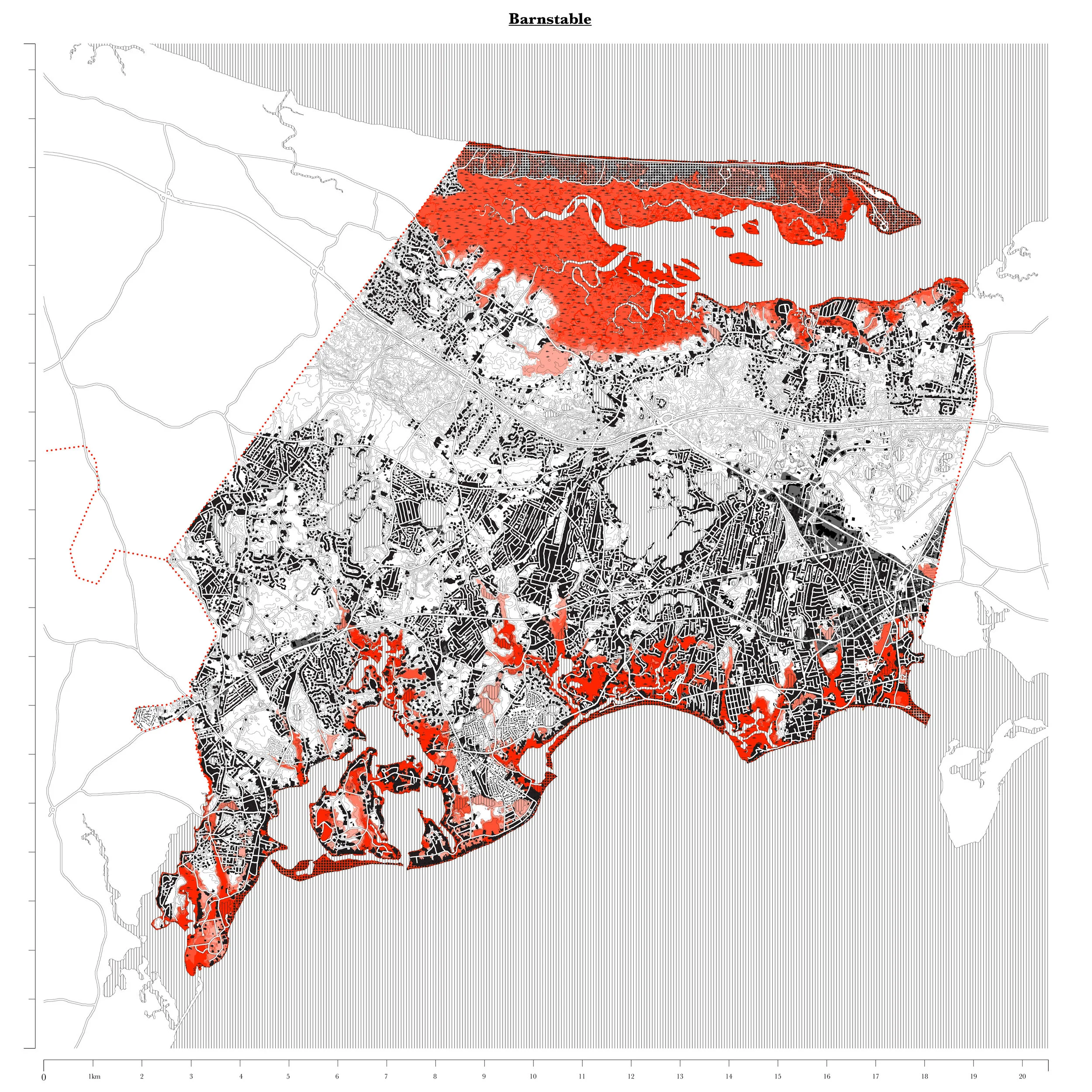
Barnstable, Massachusetts. Extent of FEMA flood zones (storm surge projections) shown in red.
ABSTRACT
Massachusetts has positioned itself as a leader in climate adaptation and mitigation action. However, there is little knowledge about how exactly climate adaptation is occurring at the local level and what barriers municipalities in the state face in implementing adaptation strategies. In response to a 2011 study on barriers to climate adaptation in coastal municipalities in Massachusetts that found ‘leadership’ and ‘values and beliefs’ as the two main barriers to adaptation, this thesis set out to ask: how, given the increase in extreme weather events and the presence of significant political leadership at the state level, have barriers to climate adaptation for coastal municipalities changed? And if the barriers have changed, what are the new barriers? The research draws on sixteen interviews with staff in six municipalities and arrives at the following findings: (i) barriers to adaptation have shifted from the understanding phase to barriers found in the implementation phase, and include the following cross cutting themes: (ii) private property interests are a significant barrier because publicly funded adaptation projects require public easements on all property that benefits from public funding; (iii) the potential of decreasing property tax revenue continues to be a concern for towns that rely on valuable waterfront property as a pillar of their municipal income; (iv) the town meeting process illuminates many concerns about equity in regards to who should pay for adaptation projects; (v) planners are aware of zoning and land use strategies for long-term adaptation, but such projects are still unpopular and unlikely to pass a town meeting vote in the near term; and (vi) uncertainty about significant damage caused by extreme weather events is more challenging to manage than slow-onset changes such as sea level rise or temperature changes. The findings lead one to believe that adaptation planning is not in fact a bureaucratic issue to be overcome with information, charts, and resources, but a much more fundamentally conceptual issue faced by a society grappling with the implications of shifting economic, social, and environmental conditions caused by climate change. By viewing the story of coastal adaptation through the unique challenges of individual towns and the experiences of the people who make these towns function, one finds that layered deep within this tension is the challenge and opportunity of restoring a highly privatized coastline to the commons. (Read full thesis here)
Thesis Supervisor: Professor Jesse Keenan, PhD, JD, LLM
Title: Lecturer in Architecture, Harvard Graduate School of Design
Climate Action Zones: Developing a New Methodology for Large-Scale Climate Action in Cities
Urban Risk Lab, MIT & University of Toronto
Poster Presented at the IPCC Cities and Climate Change Scientific Conference, March 2018
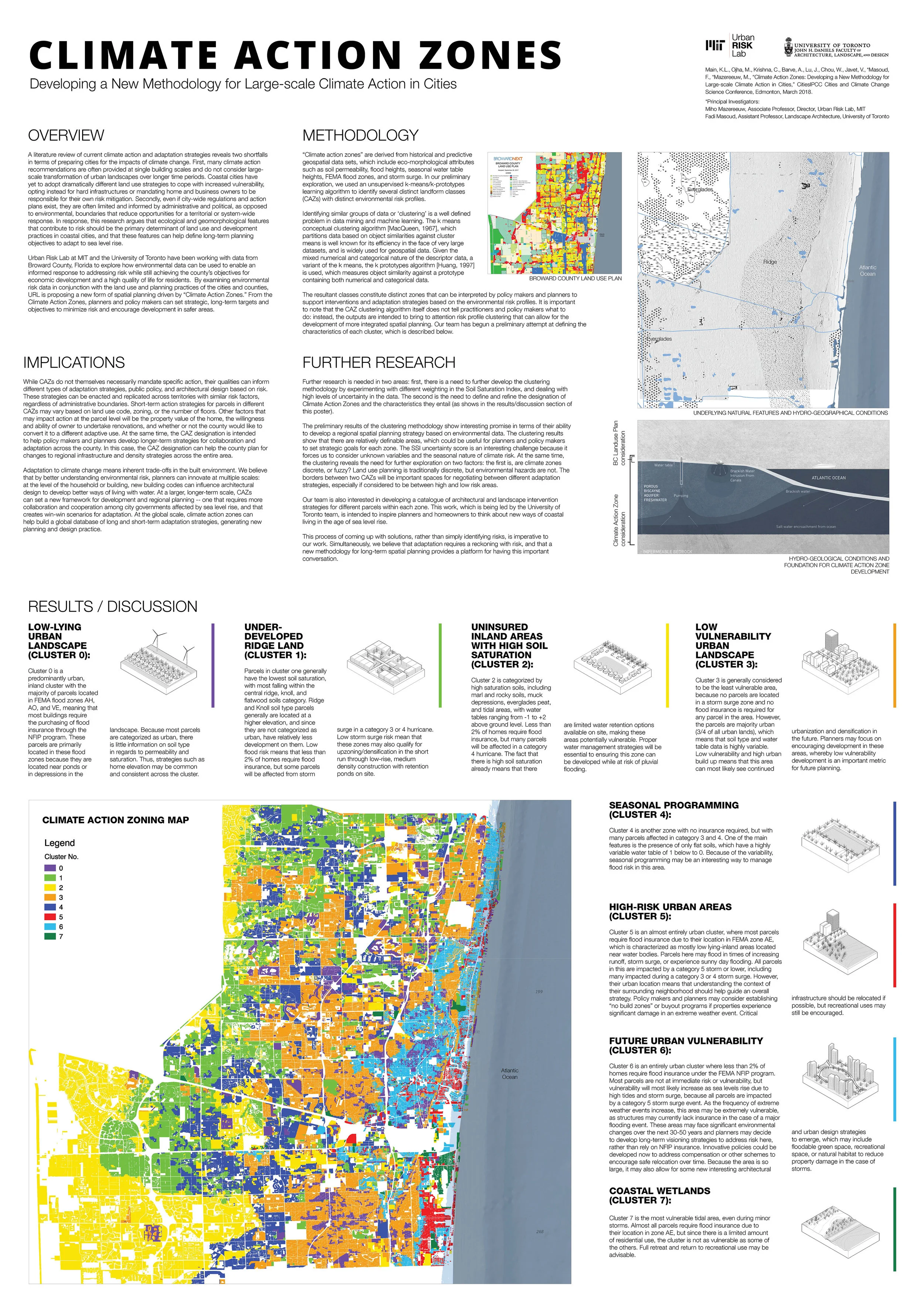
OVERVIEW
A literature review of current climate action and adaptation strategies reveals two shortfalls in terms of preparing cities for the impacts of climate change. First, many climate action recommendations are often provided at single building scales and do not consider large-scale transformation of urban landscapes over longer time periods. Coastal cities have yet to adopt dramatically different land use strategies to cope with increased vulnerability, opting instead for hard infrastructures or mandating home and business owners to be responsible for their own risk mitigation. Secondly, even if city-wide regulations and action plans exist, they are often limited and informed by administrative and political, as opposed to environmental, boundaries that reduce opportunities for a territorial or system-wide response. In response, this research argues that ecological and geomorphological features that contribute to risk should be the primary determinant of land use and development practices in coastal cities, and that these features can help define long-term planning objectives to adapt to sea level rise. Urban Risk Lab at MIT and the University of Toronto have been working with data from Broward County, Florida to explore how environmental data can be used to enable an informed response to addressing risk while still achieving the county’s objectives for economic development and a high quality of life for residents. By examining environmental risk data in conjunction with the land use and planning practices of the cities and counties, URL is proposing a new form of spatial planning driven by “Climate Action Zones.” From the Climate Action Zones, planners and policy makers can set strategic, long-term targets and objectives to minimize risk and encourage development in safer areas.